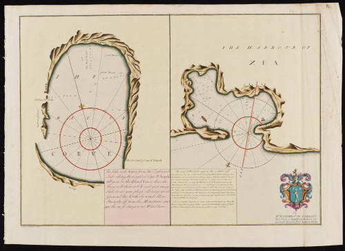
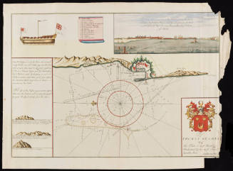
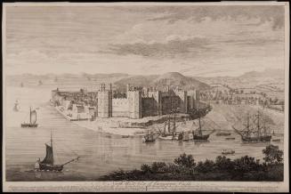
The Bay of Corve/ The Harbour of Zea
Date1730
Maker
Andrew Elton Jr.
(fl. 1715-1742)
Engraver
Bishop Roberts
(d. 1739)
OriginEngland, London
MediumLine engraving on laid paper with hand coloring
DimensionsOverall: 28 3/4 × 20 3/8 in (73.02 × 51.75cm)
Platemark: 18 1/4 × 26 in (46.35 × 66.04cm)
Platemark: 18 1/4 × 26 in (46.35 × 66.04cm)
Credit LineMuseum Purchase
Object number2026-5
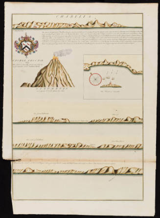
DescriptionThe lower left corner reads, “To/ Mr. Waterhouse Gibbons/ This Plate is humbly dedicated by/ his most humble Servt. Andrew Elton.”The text box in the left "Bay of Corve" section reads, "To Scale into Corve from the Eastward/ Saile along the Coast of Cape St. Angelo/ till you See the Island Corve: then the/ Bay will shew it Self and you may/ Saile in as you please, all being good/ Grounf the Northerly winds blow/ Strongly off from the Mountains and/ are the most dangerous Wind here."
The text box in the right "Harbor of Zea" section reads, "The Land & Windmills appear thus 2 Miles off/ The Haven of Zea lies on the North Side of the Island, about a League from the East End, and somewhat more than 4 Leagues from the west End thereof./ It is enclosed with high Mountains, so that it is not easily seen; and the best/ mark to know it by, is to bring the Windmills N. N.W. which stand on the/ Mountain; and then you will perceive a small House on each side of the/ Entrance; you cannot be decieved, there being no other Houses on this part of/ the Coast. Ships bound to the Westward, lye in the Easternmost part of ye Harbour./ and those to the Eastward, in the West part. It is all good Ground, and if you/ haul close in to the Shore in either part, you may lye Land Lock'd. The North/ is the worst Wind in this place./ N.B. It is somewhat dangerous to venture in here, with hard gales of Wind, the Entrance being Narrow, & your Anchors apt not to take hold, by reason of ye depth/ of Water, So that a Fast on Shore, as soon as possible, is very necessary."
The lower margin reads, "Bishop Roberts Sculp."Label TextThis chart assists sea captains in their navigation to access the Bay of Corve, the Greek island of Corfu, and the Harbour of Zea, referring to Piraeus, the port to Athens. Captain Andrew Elton, the creator of this chart, was an English sea captain associated with the Levant (or Turkey) Company, a royal chartered private syndicate that had held a monopoly over English trade with the Ottoman Empire since 1592. This chart of Corve and Zea was inserted in a Dutch composite atlas and was accompanied by seven other charts of Italian and Greek sea ports. The chart was engraved by Bishop Roberts (d. 1739) who later moved to North America, first to New Jersey and then Charleston, South Carolina. In Charleston, he drafted and engraved a view of the city. Roberts' watercolor of Charleston (CWF 1956-103) and subsequent engraving (CWF 1936-725) are both in Colonial Williamsburg's collection.Inscription(s)The top right corner reads, "141."ProvenanceBefore 2026, Barry Lawrence Ruderman Antique Maps (La Jolla, CA); 2026-present, purchased by the Colonial Williamsburg Foundation (Williamsburg, VA)
Herman Moll (1654?-1732)
ca. 1740 (originally published 1711)
William Charles
ca. 1810