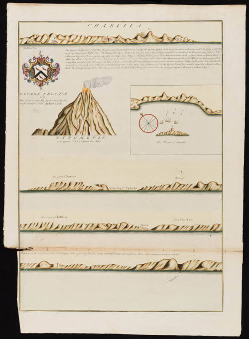
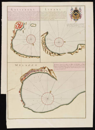
Charella / Strombulo
Date1730
Maker
Andrew Elton Jr.
(fl. 1715-1742)
Engraver
Bishop Roberts
(d. 1739)
OriginEngland, London
MediumLine engraving on laid paper with hand coloring
DimensionsOverall: 29 × 21 in (73.66 × 53.34cm)
Platemark: 25 7/8 × 18 1/4 in (65.72 × 46.35cm)
Platemark: 25 7/8 × 18 1/4 in (65.72 × 46.35cm)
Credit LineMuseum Purchase
Object number2026-1
DescriptionThe text under the coat of arms reads, "To/ George Proctor/ Esqr./ This Plate is humbly Dedicated by most Servt. Andrew Elton."The text under the first coastline reads, "Thus appears the high Land of Charella, when you come from the Westward. It is pretty flat, and the highest on the Coast. You will see a Mountain, mark'd B, riseing in three Hum/ mocks of almost equal Height. This is the Mountain Belvidera. At the same time you will see three Villages, mark'd C, on the sides of the Mountains, one of which is Cha/ rella and they are to be seen a great way off at Sea Under these Villages is the Island where you load the Belvidera Fruit. On this Island stands a Square Tower. D/ About two Miles to the Southward on a low Point by the Water side is a small Village with a Castle called the Diamond. five or six Miles from whence you will see/ a large Town mark'd E call'd Belvidera. Six Miles to the Norward of the afforsaid Island you will perceive another handsome Village by the water Side called Escalla/ mark'd F, on a low Sandy Shore at the foot of the Mountains. Two or three Miles to the Northward of Escalla lyes the Island Dio, on which stand three Houses or Towers/ Under this Island you may Anchor. The entrance in is to the Northward. Charella lyes from Strombulo S.W. 1/2 S. & you may Saile all round it with without Danger."
The lowest section of text reads, "Palacastra the Coarse is N.W. 5 or 6 Leagues, where you may Anchor under the Bluse Point with a Fast on Shore. The People are not to be trusted."
The lower margin reads, "Bishop Roberts Sculp."Label TextThis chart assisted sea captains in their navigation to access the Italian Calabrian coast, warning captains that locals could not be trusted. The chart depicts the Stromboli volcano mid-eruption and a location where traders can pick up "Belvidera Fruit" to bring back to Britain. Captain Andrew Elton (fl. 1715-1742), the creator of this chart, was associated with the Levant (or Turkey) Company, a royal chartered private syndicate that had held a monopoly over English trade with the Ottoman Empire since 1592. Captain Elton dedicated the chart to George Proctor, the owner of the Langley Estate in Norfolk and a wealthy investor in overseas ventures. This chart of the Calabrian Coast was inserted in a Dutch composite atlas and was accompanied by seven other charts of Italian and Greek sea ports.
The chart was engraved by Bishop Roberts (d. 1739), an Englishman who later moved to North America, first New Jersey and the Charleston, SC. He drafted a watercolor view of Charleston (CWF 1956-103) and created a subsequent engraving (CWF 1939-725).ProvenanceBefore 2026, Barry Lawrence Ruderman Antique Maps (La Jolla, CA); 2026-present, purchased by the Colonial Williamsburg Foundation (Williamsburg, VA)
Bishop James Madison (1749-1812)
1807