Livorno
Date1730
Engraver
Bishop Roberts
(d. 1739)
OriginEngland, London
MediumLine engraving on laid paper with hand coloring
DimensionsOverall: 20 3/4 × 28 1/2 in (52.7 × 72.39cm)
Platemark: 18 3/8 × 26 1/4 in (46.67 × 66.67cm)
Platemark: 18 3/8 × 26 1/4 in (46.67 × 66.67cm)
Credit LineMuseum Purchase
Object number2026-3
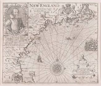
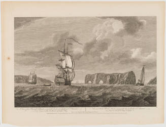
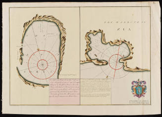
DescriptionThe top right corner reads, “Livorno when you are in the North part of the Road/ Between the Powder House and the Moletta it’s all Mudd/ in which place if Ships Drive or Run on Shore they Seldom/ get Harm.” The right lower margin reads, “To/ Thomas Heames/ Es.r/ this Plate is most Humbly/ Dedicated by his most oblig’d/ humble Serv.t/ Andrew Elton.”
The left corner reads, "From Via Reggio is a Sandy Shore, and several/ sandy Points run out a little way into the Sea,/ And as you come near to Livorno, you'l see/ St. Peter's Church before you get the length of/ the Malora sand by keeping in 5 / or 6 // Fathom water; and then you'l get sight of/ the Lantern, which must then be kept as is directed on the Card./ NB. If in the Night you see more Lights/ than one, the Lantern will be easily distinguish'd/ by your Prospect Glass from the other./ Thus appears the Island Gorgona N.N.W. 1/2 Dist. 4 or 5 Miles/ From the Gorgona to the Lantern of Livorno East Dist. 6 or 7 Leagues/ from the Gorgona to the Melora E.N.E. Dist. 5 or 6 Leagues./ Thus appears the Island of Capria W.b.S. Dist. 7 or 8 miles from/ Capria to the Lantern of Livorno N.E. Dist. 8 or 9 Leagues./ Thus appears Mount Cristo S. Dist. 7 or 8 Leagues."
Label TextThis chart depicts Livorno (called "Leghorn" by the British), a free port in Tuscany that many European merchants used as an entry point for trade with Ottoman Empire. Captain Andrew Elton, the creator of this chart, was associated with the Levant (or Turkey) Company, a royal chartered private syndicate that had held a monopoly over English trade with the Ottoman Empire since 1592. Many of these merchants (called "turkey merchants") resided in Livorno, which was a free port that allowed foreigners and people of all religions to live and work there. Turkey merchants used Livorno as a stopover, creating a merchant Anglophone community and independent commerical house based in the Italian port. The chart is dedicated to Thomas Heames (ca. 1689?-d. 1746), one of the English merchants at the factory in Livorno. This Livorno chart was inserted in a Dutch composite atlas and was accompanied by seven other charts of Italian and Greek sea ports.
The chart was engraved by Bishop Roberts (d. 1739), an Englishman who later moved to North America, first New Jersey and then Charleston, South Carolina. In Charleston, he drafted and engraved a view of the city. Roberts' watercolor of Charleston (CWF 1956-103) and subsequent engraving (CWF 1936-725) are both in the collection of Colonial Williamsburg.ProvenanceBefore 2026, Barry Lawrence Ruderman (La Jolla, CA); 2026-present, purchased by the Colonial Williamsburg Foundation (Williamsburg, VA)
1779 (dated)
Jean-Baptiste Bourguignon d'Anville (1697-1782)
June 10, 1775