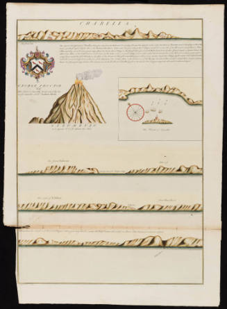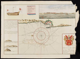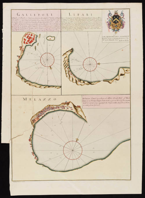
Gallipoli/ Lipari/ Melazzo
Date1730
Maker
Andrew Elton Jr.
(fl. 1715-1742)
Engraver
Bishop Roberts
(d. 1739)
OriginEngland, London
MediumLine engraving on laid paper with hand coloring
DimensionsOverall: 28 3/8 × 21 in (72.07 × 53.34cm)
Platemark: 25 7/8 × 18 1/4 in (65.72 × 46.35cm)
Platemark: 25 7/8 × 18 1/4 in (65.72 × 46.35cm)
Credit LineMuseum Purchase
Object number2026-2
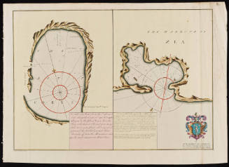
DescriptionThe top right corner reads, "To Chamberlain Godfrey/ Esq.r This Plate is humbly Dedicated by his most Humble Serv.t/ Andrew Elton."Under the title Gallipoli reads, "Gallipoli, or Callipolis, is seated on a Rock on the Gulph of Tarento, & though/ it be small it is a very strong & well inhabited Place, being surrounded by ye Sea except/ at one place where it is joyn'd to ye Land by a Bridge defended by a Fort or Castle. It/ is 25 Miles distant from Oranto, to the West 36 from Tarento to the South East, &/ 24 from the Promontory called Capo di Marcadi di Luca, & is an Episcopal/ See under the Archbishop of Oranto, but the Bounds of ye Diocess reach no further/ than ye City the Harbour is said to have been choack'd up by ye Venetians in ye 16th century."
Under the title Lipari reads, "Lipari is the largest of all the Aeolian or Vulcanian Islands, being 18 Miles/ in Compass It is about 40 Miles distant from the North Coast of Sicily and/ 50 from the nearest part of the further Calabria. This Island formerly vomited/ out Fire, as may still be seen by the Marks thereof. There is a Town in it of ye/ same Name, which was almost destroy'd by Barbarosa the Turkish Admiral in/ the Year 1544, but it was afterward repaired and is now a well inhabited/ place, with a Strong Fort called la Pignatara. Pope Eugemius III erected it into/ a Bishoprick, in the Year 1151. Since the year 1687, it has been exempted/ from the Jurisdiction of the Archbishop of Messina, till of late that it/ owns its Subjection to that Metropolitan."
The box of text near Melazzo reads, "Melazzo Seated on a Bay 18 Miles North West of Mes/ sina, is a strong Large Town with a good Road ye Germans/ held it out in 1719 against the Spaniards and forc'd them/ to retire from before it."
The lower margin reads, "Bishop Roberts Sculp."Label TextThis chart assists sea captains in their navigation to access the Italian coastal towns of Gallipoli, Lipari (one of the Aeolian Islands) and Melazzo (modern day Milazzo). Along with directions, the charts note town history, political situation, natural features, and nearby locations. Captain Andrew Elton, the creator of this chart, was associated with the Levant (or Turkey) Company, a royal chartered private syndicate that had held a monopoly over English trade with the Ottoman Empire since 1592. He dedicated this chart to Chamberlain Godfrey (ca. 1699-1766), a merchant who periodically resided in Livorno, an Italian free port that housed many English merchants of the Levant Company. This chart was inserted in a Dutch composite atlas and accompanied by seven other charts of Italian and Greek sea ports. The chart was engraved by Bishop Roberts (d. 1739) who later moved to North America, first New Jersey and then Charleston, South Carolina. In Charleston, he drafted and engraved a view of the city. Roberts' watercolor of Charleston (CWF 1956-103) and subsequent engraving (CWF 1936-725) are both in the collection of Colonial Williamsburg.ProvenanceBefore 2026, Barry Lawrence Ruderman Antique Maps (La Jolla, CA); 2026-present, purchased by The Colonial Williamsburg Foundation (Williamsburg, VA)

1779 (dated)