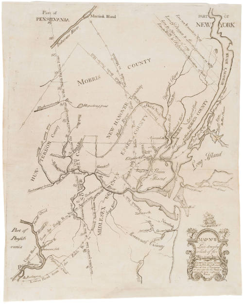
Map No. II (Map of New Jersey and New York)
Date1747
Compiler
Lewis Evans (ca. 1700-1756)
Engraver
James Turner (1722-1759)
Cartographer
James Alexander (1691-1756)
MediumLine engraving on laid paper
DimensionsOverall: 18 × 14 3/8in. (45.7 × 36.5cm)
Credit LineMuseum Purchase
Object number2019-88
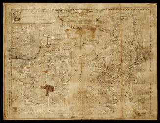
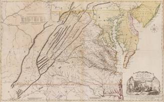
DescriptionCartouche reads: "MAP N.o II/ Laid down by/ a Seale fo five/ MilesLabel TextThis map, along with Map No. I (1992-29) and Map No. III (2019-87) was inserted in the 1747 book "A Bill in the Chancery of New-Jersey at the Suit of John of Stair..." The book sought to prove that the Board of Proprietors of the Eastern Division of New Jersey held land rights in Elizabeth Town (today Elizabeth), New Jersey over yeomen inhabitants. James Alexander, a Scottish-born lawyer and politician, led the effort to create a bill that would enforce the payment of quit-rents and subsequent evictions. After the proprietors began evictions, land claimants rioted and accused the proprietors of greed. Alexander proposed the bill's publication to defend against these accusations of greed. Three maps would clarify convoluted land claims and impose a proprietary vision of land possession. Upon Benjamin Franklin's advice that "the maps cannot be had in this country done otherwise by hand," Alexander decided the maps could only be produced by hand and commissioned Lewis Evans, a Philadelphia-based surveyor and geographer, to hand draw the three maps. Soon, however, New York printer James Parker secured a deal to reduce the cost of paper. Now, two hundred and fifty engraved maps, instead of forty hand-drawn ones, could be produced at a similar price point. Alexander hired James Turner, a Boston engraver and silversmith, to engrave the map copperplates.Map No. II focuses on the disputed lands, including Northeast New Jersey with parts of Pennsylvania and New York. The map depicts early survey and boundary lines, Indian paths, roads, towns, and waterways. Boundary lines highlight lands purchased from Munsee sachems by Dutch subjects, such as Staten Island and Bergen County. Sectioned off with a yellow boundary (colored in other versions according to Map No. I's key), the "greatest part of the Lands in Question by this Bill" was purchased from the Delawares by a Dutch subject named Augustine Herrman in 1651. The yellow boundary encircles the Elizabethtown tract. The proprietors argued that because a Munsee sachem named Mattano deeded the land to Herrman, he could not also sell the land to the original Elizabeth Town purchasers.ProvenanceBefore 2019, Martayan Lan Augustyn, Inc (New York, NY); 2019-present, purchased by the Colonial Williamsburg Foundation (Williamsburg, VA)
Lewis Evans (ca. 1700-1756)
1737-1738
Joshua Fry (ca. 1700-1754) & Peter Jefferson (1708-1757)
1768; first published ca. 1753
John Thornton
1723-1728, originally published ca. 1701
Associated Object/Associated Object