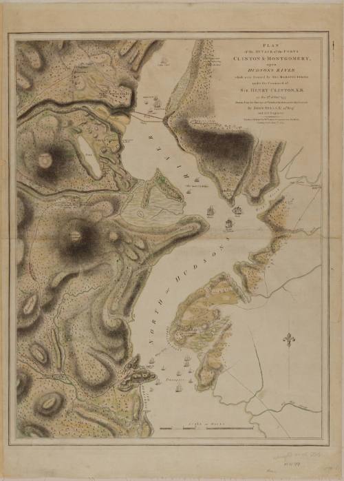
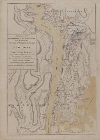
PLAN of the ATTACK of the FORTS CLINTON & MONTGOMERY, upon HUDSONS RIVER which were Stormed by HIS MAJESTYS FORCES under the Command of SIR HENRY CLINTON, K. B. on the 6.th of Oct.r 1777.
Date1784
Cartographer
Lieutenant John Hills (fl. 1777-1817)
Publisher
William Faden (1750-1836)
OriginEngland, London
MediumLine engraving on laid paper with hand coloring
DimensionsOverall: 26 3/4 × 20 3/4in. (67.9 × 52.7cm)
Framed: 36 1/4 × 29 5/8 × 1in.
Framed: 36 1/4 × 29 5/8 × 1in.
Credit LineMuseum Purchase
Object number1985-164
DescriptionThe text in the upper right corner reads: "PLAN/ of the ATTACK of the FORTS/ CLINTON & MONTGOMERY,/ upon/ HUDSONS RIVER/ which were Stormed by HIS MAJESTYS FORCES/ under the Command of/ SIR HENRY CLINTON, K. B./ on the 6.th of Oct.r 1777./ Drawn from the Surveys of VERPLANK, HOLLAND & METCALFE./ By JOHN HILL, L.t 23.d Reg.t/ and Ass.t Engineer./ London, Published by W.M FADEN, Geographer to the KING;/ Charing Cross, June 1.st 1784."Label TextThe British campaign of 1777 focused once again on the northern colonies. Major General John Burgoyne elected to stage an invasion from Quebec using the route from Lake Champlain and the Hudson River. The general experienced numerous difficulties during his southward march, particularly from the Americans encamped along the heights of the Hudson. As a diversion, Sir Henry Clinton decided to send troops up the Hudson by boat.ProvenanceBefore 1985, Richard B. Arkway, Inc. (New York, NY); 1985-present, purchased by the Colonial Williamsburg Foundation (Williamsburg, VA).

Sir Godfrey Kneller (1646-1723)
1733

A View in Hudson's River of Pakepsey & the Catts-Kill Mountains, From Sopos Island in Hudson's River
Paul Sandby (1725-1809)
ca. 1768

ca. 1805