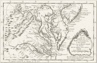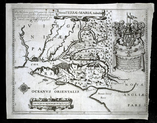
Noua TERRÆ-MARIÆ tabula
Date1671
Publisher
John Ogilby (1600-1676)
OriginEngland, London
MediumBlack and white line engraving on laid paper
DimensionsOH: 11 3/4" x OW: 15 1/8"
Credit LineMuseum Purchase
Object number1984-211
DescriptionThe upper center cartouche reads: "Noua TERRÆ-MARIÆ tabula"The banner beneath the upper right coat of arms reads: "The Atchieument of the Right Honoura.ble/ Cæcilius Calvert Baron Baltemore/ de Baltemore Absolute Lord and/ Proprietary of the Provinces of Maryland, and Avalon."
Text in the upper left corner reads: "This Northerne part of Virginia (the limitts/ whereof extend farther Southwards.) is heere/ inserted for the better description of the/ entrance into the Bay of Chesapeack."Label Textin 1632, Charles I granted a charter to Cecil Calvert, Lord Baltimore, for the province of Maryland, and by the summer of 1634, the Calverts had established their first colony. The colony was so prosperous that, according to Papenfuse and Coale in their "Atlas of Historical Maps of Maryland, 1608-1908," more than 25,000 people left England between 1634 and 1681 for Maryland alone. This map, a second edition of Lord Baltimore's map, illustrates the boundaries of his grant and many of the counties that had been established by 1671. The controversies over the boundaries of Maryland, however, would continue for more than two centuries.Mark(s)WatermarkProvenanceBefore 1984, Kenneth Nebenzahl (Chicago, IL); 1984-present, purchased by the Colonial Williamsburg Foundation (Williamsburg, VA).
1702-1714
Lewis Evans (ca. 1700-1756)
1737-1738