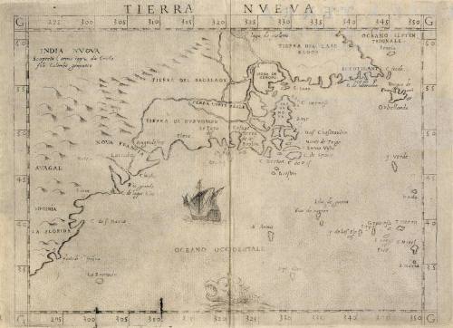
TIERRA NVEVA
Date1599
Maker
Girolamo Ruscelli
OriginEurope, Italy, Venice
MediumBlack and white line engraving
DimensionsOH: 8 11/16" x OW: 12 13/16 "
Credit LineGift of Mr. and Mrs. Richard F. Barry, III, Mr. and Mrs. Macon F. Brock, Mr. and Mrs. David R. Goode, Mr. and Mrs. Conrad M. Hall, Mr. and Mrs. Thomas G. Johnson, Jr., Mr. and Mrs. Charles W. Moorman, IV, and Mr. and Mrs. Richard D. Roberts.
Object number2017-193
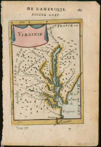
DescriptionUpper margin reads: "TIERRA NVEVA"Label TextThe first state of this map was published in 1561 and was included in Girolamo Ruscelli's edition of Ptolemy's Geography. State two was published in 1574 and was re-touched to include cross-hatched graduation marks. The second state was also cut, creating a plate mark across the top. This map is a third state, which was potentially the rarest of the three states. This later edition includes recently named "Virginia." It is one of a handful of 16th century maps to list Virginia by name. The plate was also re-engraved to include a ship and a sea monster. This copy is published in William C. Wooldridge, "Mapping Virginia: From the Age of Exploration to the Civil War" (Charlottesville: University of Virginia Press, 2012), #4, pp. 4-7.ProvenanceBefore 1990, W. J. Faupel (Sussex, England); 1990, purchased by William C. Wooldridge (Norfolk, VA); 2009, purchased by the Virginia Cartographical Society (Norfolk, VA); 2017-present, given to the Colonial Williamsburg Foundation (Williamsburg, VA).
Robert Sayer (1725-1794) & John Bennett (fl. 1760-1787)
1776
Phillip Lea (fl. 1666-1700, d. 1700)
ca. 1698