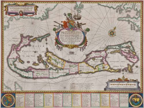
Mappa AESTIVARUM Insularum,/ alias BARMUDAS dictarum, ad Ostia/ Mexicani aestuary jacentium...
Date1630
Engraver
Willem Janszoon Blaeu
1571 - 1638
MediumBlack and white line engraving with period hand color on laid paper.
DimensionsOverall: OH: 21" x OW: 24 5/8"; To neat lines: 15 3/8" X 20 3/8"
Credit LineMuseum Purchase
Object number2017-61
DescriptionThe central cartouche reads: "Mappa AESTIVARUM Insularum,/ alias BARMUDAS dictarum, ad Ostia/ Mexicani aestuary jacentium in latitudine Gra:/ duum 32 Minutorum 25. Ab Anglia, Londino/ Scilicet versus Libonotum 3300 Miliaribus/ Anglicanis, et a Roanoack (qui locus est/ in Virginia) versus Euronotum 500 Mill./ accurate descripta."The upper left cartouche reads: "Scala Milliarium ad intervallum metiendum, inter AESstivas Insulas et Virginiam Novam/ Anglicam, et Hispaniolam, omnes simul caelatura lenni, subtiliq 2. sculptas, et delineatas."
The lower right cartouche reads: "Scala trium Miliarum vel vigintiquatuor Stadiorum./ Amstelodami Guiljelm Blaeuw excudit."Label TextThis map of Bermuda is based on John Norwood's lost survey of 1618. In 1612, the Third Virginia Charter extended the boundaries of Virginia 1,000 miles off-shore to encompass Bermuda. Though this association did not long, Blaeu highlighted the connection by representing the coast of Virginia (now North Carolina and the Outer Banks) at the top right-hand corner of the map. Further solidifying the Virginia connection is the decorative seal of the Virginia Colony (bottom right) and the table at the bottom includes a complete list of proprietors and their shares along with a key which identifies the location of each property on the map.1
1. William C. Wooldridge, Mapping Virginia: From the Age of Exploration to the Civil War (Charlottesville: University of Virginia Press, 2012), p 57-58, #50 (this copy is depicted).ProvenanceBefore 2005, Sanderus Antique Maps (Ghent, Belgium); 2005, purchased by William C. Wooldridge (Norfolk, VA); 2009, purchased by the Virginia Cartographical Society (Norfolk, VA); 2017-present, purchased by the Colonial Williamsburg Foundation (Williamsburg, VA).
Jodocus Hondius I
First published 1606; This example: 1634