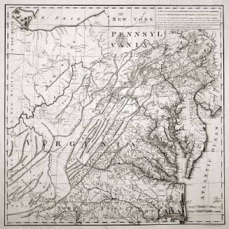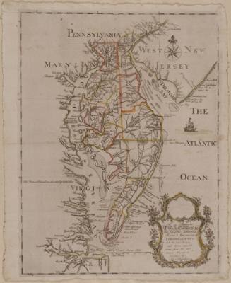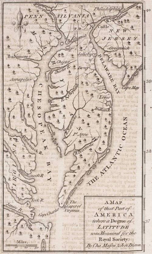
A Map of that Part of America where a Degree of Latitude was Measured for the Royal Society: By Cha. Mason & Jere. Dixon
Date1769
Attributed to
James Mynde
Cartographer
Jeremiah Dixon
Cartographer
Charles Mason
OriginEngland, London
MediumBlack and white line engraving
DimensionsTo the neat lines: 6 1/2" x 3 3/4"
Credit LineMuseum Purchase
Object number2017-107
DescriptionCartouche reads: "A MAP/ of that Part of/ AMERICA/ wehre a Degree of/ LATITUDE/ was Measured for the/ Royal Society:/ By Cha/ Mason, & Jere. Dixon."Label TextThis map depicting Charles Mason and Jeremiah Dixon's survey that determined the boundary between Pennsylvania and Maryland after decades of bitter dispute. It was originally published in “The Gentleman's Magazine," December 1769, (London: printed for D. Henry at St. John's Gate) with an article describing their methods of calculating what is now known as the "Mason Dixon Line." One of the disputes over the limits of Lord Baltimore's grant, involving the eastern and northern boundaries of Maryland, occurred when William Penn was granted a charter for Pennsylvania in 1680. Penn and his lawyers disputed the Dutch settlements on the east side of the Delmarva Peninsula. They also questioned whether the northern boundary should be at the fortieth degree of latitude as accurately surveyed or at the latitude where it was thought to have been in 1632 when Lord Baltimore's charter was granted. (See cataloging for Senex, 1732 G1984-43). After decades of disagreement over accurate boundary surveys, the commissioners for both parties sought advice from James Bradley, the Royal Astronomer at Greenwich in England. In the early 1760s, he proposed that Charles Mason (one of his assistants) and Jeremiah Dixon to take on the task.
Mason and Dixon arrived in Pennsylvania in 1763 with the most state-of-the-art surveying and astronomical equipment in tow to settle the dispute once and for all. Their mission was to accurately survey the tangent line northward from the middle point of the transpeninsular line to the twelve-mile arc, and survey the east-west boundary five degrees westward along a line of latitude passing fifteen miles south of the sourthernmost part of Philadelphia.
This copy was published in William C. Wooldridge, "Mapping Virginia: From the Age of Exploration to the Civil War," (Charlottesville: University of Virginia Press, 2012), #109, p. 114.ProvenanceBefore 1999, Dick and Donna Haines, Village Antiques (Mt. Sidney, VA); 1999, purchased by William C. Wooldridge (Norfolk, VA); 2009, purchased by the Virginia Cartographical Society (Norfolk, VA); 2017-present, purchased by the Colonial Williamsburg Foundation (Williamsburg, VA).