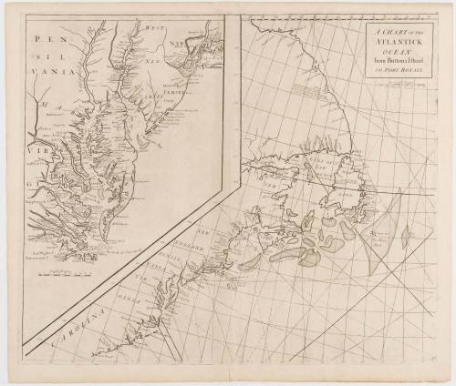
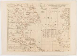
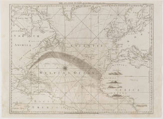
A Chart of the Atlantick Ocean From Buttons Island to Port Royall
Date1728
Engraver
Nathaniel Cutler
Maker
Edmond Halley
1656 - 1742
OriginEngland, London
MediumLine engraving on laid paper
DimensionsOverall: 21 × 24 1/2in. (53.3 × 62.2cm)
Credit LineMuseum Purchase
Object number2017-94
DescriptionCartouche (upper right): "A CHART OF THE/ ATLANTICK/ OCEAN/ from Buttons Island/ TO PORT ROYALL"Label TextThis maritime chart shows the eastern seaboard of North American from the Carolinas to Labrador, featuring an enlarged inset of the Chesapeake Bay. It was published in the 1728 "Atlas maritimus & commercialis; or, A general view of the world, so far as relates to trade and navigation" by cartographers Nathaniel Cutler and Edmond Halley. The maps in this atlas drew on Cutler's new "globular projection," which was more accurate than other projections used at the time.
Photo: Detail of Inset.
This copy is published in William C. Wooldridge, Mapping Virginia: From the Age of Exploration to the Civil War (Charlottesville: University of Virginia Press, 2012), #93, pp. 96-97.ProvenanceBefore 1992, Jonathan Potter Ltd (London, England); 1992, purchased by William C. Wooldridge (Norfolk, VA); 2009, purchased by the Virginia Cartographical Society (Norfolk, VA); 2017-present, purchased by the Colonial Williamsburg Foundation (Williamsburg, VA).

Herman Moll (1654?-1732)
ca. 1740 (originally published 1711)

Edward Wells (1667-1727)
1700-1701
Governor Thomas Pownall (bapt. 1722-1805)
September 20, 1787