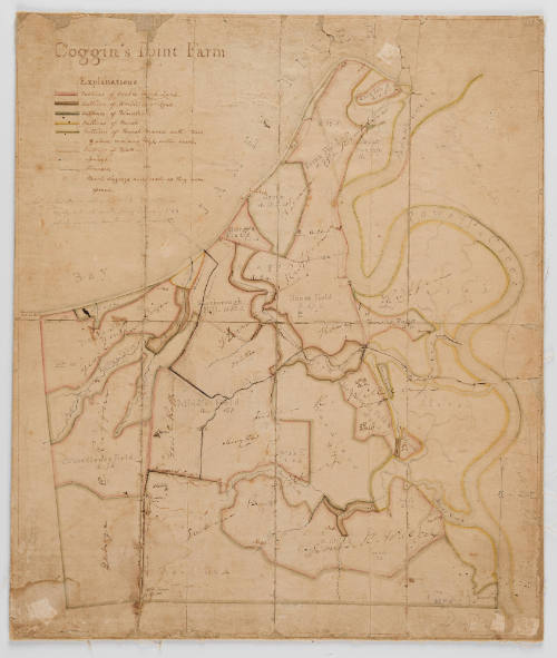
Coggin's Point Farm
Date1813-1823
Attributed to
Edmund Ruffin
1794 - 1865
MediumInk and watercolor on paper mounted on linen
DimensionsOH: 19" x OW: 16"
Credit LineGift of Fred Kelly and Carol Dill
Object number2005-15,A&B
DescriptionThe upper left corner reads: "Coggin's Point Farm" with a key below that reads: "Outlines of Arable High Land./ Outlines of Arable Low Land./ Outlines of Woodlands./ Outlins of March/ Outlines of Marsh covered with trees,/ & above common high water mark./ Outlines of Water./ Springs/ Streams./ Marl diggings, numbered as they were opened./ The Fields surveyed 1823_The OUtlines/ nearly, but not exactly, from a survey of 1783,/ which has since been found very incorrect."Label TextThis manuscript map depicts Coggins Point Farm, a property in Prince George County, Virginia, inherited by Edward Ruffin in 1813. It documents Ruffin's agricultural experiments on the property as well as land ownership in the area.ProvenanceProbably 1813/1823-1865, Edmund Ruffin [1794-1865] (Prince George County, VA); dates unknown, possibly to his son Edmund Ruffin, Jr. [1814-1876]; dates unknown, possibly to his son George Champion Ruffin [1845-1913]; dates unknown, possibly to his daughter Virginia Ruffin [1880-?]; dates unknown, to her son James Skelton Gilliam Jr. [1910-2000]; 2000-2005; to his cousin Fred Kelly and his wife Carol Dill (Stoney Creek); 2005-present, given to the Colonial Williamsburg Foundation (Williamsburg, VA).
1700-1725
1825-1850
19th century
Possibly 1900-1930
1750-1780
1730-1740
ca. 1850