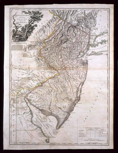
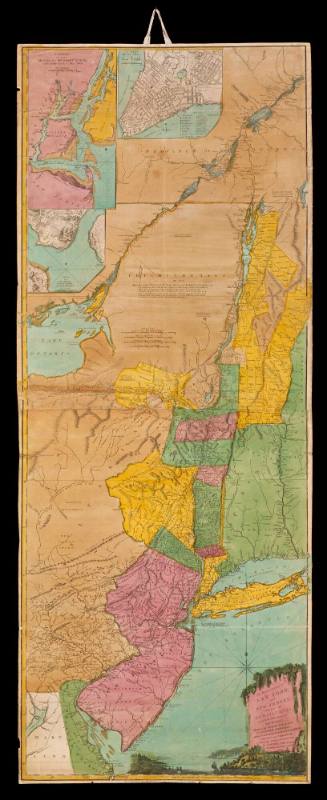
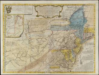
THE/ PROVINCE of NEW JERSEY,/ Divided into/ EAST and WEST,/ commonly called/ THE JERSEYS.
DateDecember 1, 1777
Cartographer
William Faden (1750-1836)
After work by
Bernard Ratzer
After work by
Gerard Bancker
1740 - 1799
Engraver
William Faden (1750-1836)
OriginEngland, London
MediumBlack and white line engraving with period hand color on laid paper
DimensionsOH: 31 1/2" x OW: 23"
Credit LineMuseum Purchase
Object number1986-121
DescriptionThe upper left cartouche reads: "THE/ PROVINCE of NEW JERSEY,/ Divided into/ EAST and WEST,/ commonly called/ THE JERSEYS."The text below the cartouche reads: "Engraved & Published by W.M FADEN, Charing Cross,/ December 1.st 1777./ This Map has been drawn from the Survey/ made in 1769 by order of the Commissioners/ appointed to settle the partition Line between/ the Provinces of New York & New Jersey by/ Bernard Ratzer, Lieut.t in the 60.th Reg.t and/ from another large Survey of the Northern/ Parts in the possession of the Earl of Dunmore/ by Gerard Banker. The whole regulated and/ ascertained by Astronomical observations."ProvenanceBefore 1986, W. Graham Arader III (New York, NY); 1986-present, purchased by the Colonial Williamsburg Foundation (Williamsburg, VA).
Joshua Fry (ca. 1700-1754) & Peter Jefferson (1708-1757)
1768; first published ca. 1753
Robert Sayer (1725-1794) & John Bennett (fl. 1760-1787)
1776
Major Samuel Holland (1728-1801)
August 17, 1776
Joseph Frederick Wallet Des Barres
1780
Bernard Ratzer
January 12, 1776

John Thornton
1723-1728, originally published ca. 1701