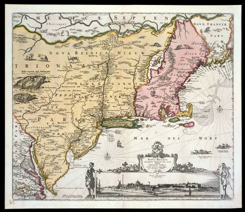
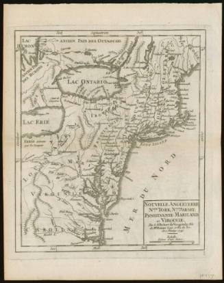
NOVI BELGII/ NOVÆQUE ANGLIÆ NEC NON/ PARTIS/ VIRGINIÆ TABULA/ multis in locis emendata/ per Nicolaum Visscher.
Dateca. 1684; originally published ca. 1655
Cartographer
Nicolas Visscher (1618-1679)
After work by
Jan Jansson
1588 - 1664
MediumBlack and white line engraving with period hand color on laid paper
DimensionsOH: 18 3/16" x OW: 21 1/2"
Credit LineMuseum Purchase
Object number1968-129
DescriptionThe lower right cartouche reads: "NOVI BELGII/ NOVÆQUE ANGLIÆ NEC NON/ PARTIS/ VIRGINIÆ TABULA/ multis in locis emendata/ per Nicolaum Visscher."Text to the right of Virginia's Eastern Shore reads: "cum Privil: Ordin: General: Belgii Fæderati."Label TextBeautifully decorated with Indian villages, animals, natives, and an interesting view of New York, this map is perhaps best known for its connection with the boundary disputes between the Penns and Lord Baltimore. This map was the source for Lord Baltimore's map to substantiate his claims. Unfortunately for him, the map places Cape Henlopen much farther south than it actually is and this feature was incorporated into Baltimore's map. In 1685, the king had decreed that the southern boundary of the Penns' grant was to extend from Cape Henlopen to the center of the peninsula. Thus, Lord Baltimore lost thousands of acres of land.Inscription(s)On reverse: "F.F."ProvenanceBefore 1968, the Old Print Shop (New York, NY); 1968-present, purchased by the Colonial Williamsburg Foundation (Williamsburg, VA).
Nicolas Visscher (1618-1679)
1657
Abraham Ortelius (1527-1598)
1592 (originally published 1587)
1760-1763
ca. 1776-1777