Map No. III (Map of New Jersey)
Date1747
Engraver
James Turner (1722-1759)
Compiler
Lewis Evans (ca. 1700-1756)
Maker
James Alexander (1691-1756)
MediumLine engraving on laid paper
DimensionsOverall: 14 × 25 3/8in. (35.6 × 64.5cm)
Other (Plate): 11 1/4 × 24 1/4in. (28.6 × 61.6cm)
Other (Plate): 11 1/4 × 24 1/4in. (28.6 × 61.6cm)
Credit LineMuseum Purchase
Object number2019-87
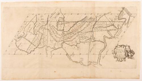
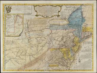
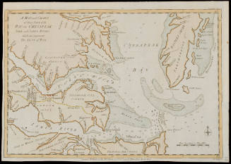
DescriptionIn cartouche: "MAP N.o III./ Protracted by a/ Scale of 150 Chains/ to an Inch/ Engrav'd & Printed/ by James Turner near the/ Town House BOSTON./ N England"Label TextThis map, along with Map No. I (1992-29) and Map No. III (2019-87) was inserted in the 1747 book "A Bill in the Chancery of New-Jersey at the Suit of John of Stair..." The book sought to prove that the Board of Proprietors of the Eastern Division of New Jersey held land rights in Elizabeth Town (today Elizabeth), New Jersey over yeomen inhabitants. James Alexander, a Scottish-born lawyer and politician, led the effort to create a bill that would enforce the payment of quit-rents and subsequent evictions. After the proprietors began evictions, land claimants rioted and accused the proprietors of greed. Alexander proposed the bill's publication to defend against these accusations of greed. Three maps would clarify convoluted land claims and impose a proprietary vision of land possession. Upon Benjamin Franklin's advice that "the maps cannot be had in this country done otherwise by hand," Alexander decided the maps could only be produced by hand and commissioned Lewis Evans, a Philadelphia-based surveyor and geographer, to hand draw the three maps. Soon, however, New York printer James Parker secured a deal to reduce the cost of paper. Now, two hundred and fifty engraved maps, instead of forty hand-drawn ones, could be produced at a similar price point. Alexander hired James Turner, a Boston engraver and silversmith, to engrave the map copperplates.Map No. III represents the entirely of the Elizabeth Town tract, detailing various land surveys and purchases made between 1676 and 1743. The map focuses solely on the land holdings of the proprietors and no longer has iconography of towns, cities, Indian paths, and forts. Many lots are sectioned off and labeled with numbers and/or names. The numbers and names correspond with a chart in the "Bill in the Chancery of New-Jersey" titled "Schedule No. III" and specifically outline the proprietors' claims to contested lands. Schedule No. III locates tracts through a grid system on the map organized by the "complainants," or proprietors hoping to reclaim their tracts, the surveyors, and the land surveyed and situation.ProvenanceBefore 2019, Martayan Lan Augustyn, Inc. (New York, NY); 2019-present, purchased by the Colonial Williamsburg Foundation (Williamsburg, VA)
Bishop James Madison (1749-1812)
1807
John Lodge (fl. 1754-1796)
1781
Joshua Fry (ca. 1700-1754) & Peter Jefferson (1708-1757)
1768; first published ca. 1753
John Thornton
1723-1728, originally published ca. 1701
Associated Object/Associated Object