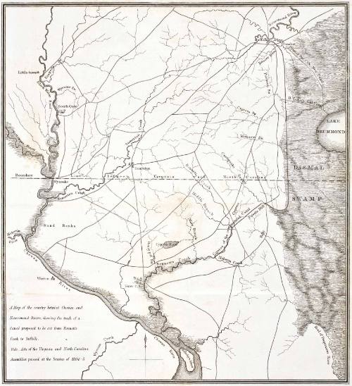
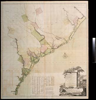
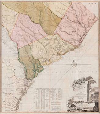
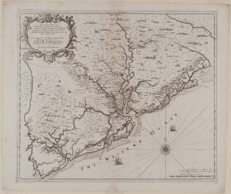
A Map of the country betwixt Chowan and Nansemond Rivers, shewing the track of a Canal proposed to be cut from Bennett's Creek to Suffolk
Date1805/1834
MediumBlack and white engraving
DimensionsOH: 13 1/4" x OW: 16 1/2"
Credit LineMuseum Purchase
Object number2017-164
DescriptionLower left cartouche reads: "A Map of the county betixt Chowan and / Nansemind Rivers, showing the trade of a / Canal proposed to be cut from Bennett's / Creek to Suffolk. / Vide. Acts of Virginia and North Carolina / Assembilies passed at the Session of 1804-5."Label TextThis map by an unknown maker was orignally published in 1805, it appears to have been republished in 1834. The map shows a "contemplated" canal from Suffolk to North Carolina, indicated by the details in the map's cartouche. The 1807 map published by Bishop James Madison in 1807 map also shows the same "comtemplated" canal running from Suffolk into North Carolina. Published only a few years before the map by Madison (2017-284, A&B), which shows Virginia's expansion since the Jefferson-Fry map (1968-11), published in 1753, this map is another example of Virginia's growth and settlement into the 19th century. This copy is published in William C. Wooldridge, Mapping Virginia: From the Age of Exploration to the Civil War (Charlottesville: University of Virginia Press, 2012), pp. 199-202, #186ProvenanceBefore 2002, New World Maps (Lake Worth, FL); 2002, purchased by William C. Wooldridge (Norfolk, VA); 2009, purchased by the Virginia Cartographical Society (Norfolk, VA); 2017-present, purchased by the Colonial Williamsburg Foundation (Williamsburg, VA).
Robert Sayer (1725-1794)
1755-1775
1754

Probably 1857-1865