
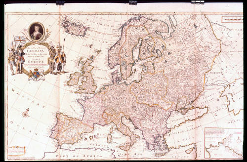
To Her most Sacred MAJESTY/ CAROLINA/ QUEEN of GREAT BRITAIN,/ FRANCE & IRELAND./ This MAP of/ EUROPE/ According to the Newest and most Exact Observations...
Dateca. 1732-1748
Cartographer
Herman Moll (1654?-1732)
Publisher
Herman Moll (1654?-1732)
Publisher
John Bowles
1701 - 1779
Publisher
Thomas Bowles II
ca.1689 - 1767
Publisher
Philip Overton
d. 1751
Publisher
John King
1698 - 1748
OriginEngland, London
MediumBlack and white line engraving with period hand color on laid paper
DimensionsOH: 24 1/2" x OW: 38 5/8" (framed); Plate H: 23" x W: 38"
Credit LineMuseum Purchase
Object number1979-286
DescriptionThe upper left cartouche reads: "To Her most Sacred MAJESTY/ CAROLINA/ QUEEN of GREAT BRITAIN,/ FRANCE & IRELAND./ This MAP of/ EUROPE/ According to the Newest and most Exact Observations/ is most Humbly Dedicated by your Majesties most Obedient/ Servant Herman Moll Geographer."The lower left cartouche reads: "Printed for I. Bowles Print and Map/ seller at the Black Horse in COrnhill/ and T. Bowles Print & Mapseller/ next to the Chapter house in S.t Pauls/ Church yard./ 1708."
The text below the lower left cartouche reads: "Sold by H. Moll over against Devereux Court without Temple Bar./ and P. Overton Map & Printseller near S.t Dunstans Church Fleetstreet/ and by I. King Map & Printseller at y.e Globe in the Poultry."ProvenanceBefore 1979, The Map House (London, England); 1979-present, purchased by the Colonial Williamsburg Foundation (Williamsburg, VA).
Herman Moll (1654?-1732)
After 1735; originally published 1715
Robert Sayer (1725-1794) & John Bennett (fl. 1760-1787)
1776
Herman Moll (1654?-1732)
1740-1745 (originally published 1715)
Herman Moll (1654?-1732)
ca. 1740 (originally published 1711)

